Vectorization of geological materials

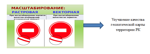
Vectorization is the conversion of an image from raster format to vector. It is carried out, as a rule, if the result of vectorization is subject to further processing in vector graphics programs; to improve image quality; to create an image suitable for scaling without loss of quality; if further image processing will be carried out in specialized programs.
Some modern programs have a built-in ability to automatically digitize/trace a vector image, but manual drawing is often preferable for greater accuracy of the resulting data.
It is more correct to consider the vectorization process as more complex, in contrast to rasterization, which can almost always be performed completely automatically.
Vectorization is carried out in geographic information systems using the digitization of a raster image; the resulting objects can be polygonal, linear or point.
Vectorization of geological reports provides the opportunity to replenish and enrich the Department’s database due to the availability of information on fields with approved reserves, issued contract territories, changes in contracts, as well as information on the vacancy of the territory based on the availability of acts of return to previously handed over contract territories.
Necessity of vectorization:
Visual accounting and automated monitoring of the state of the state subsoil fund
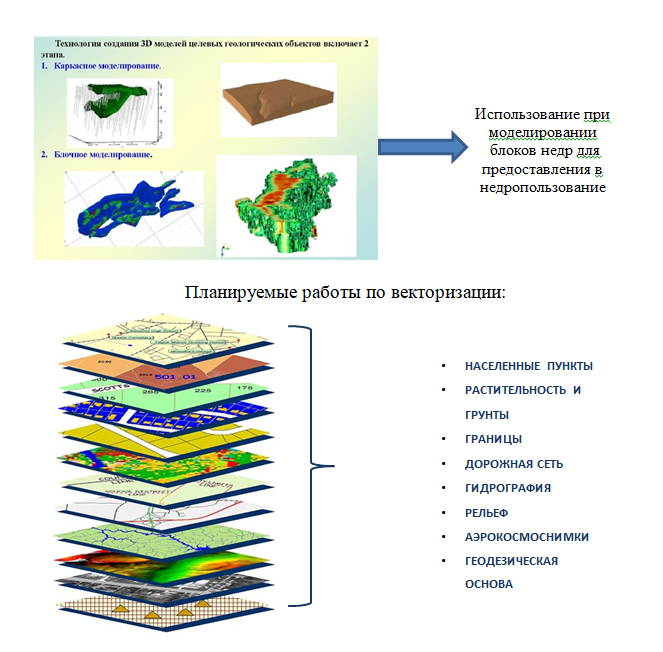
Vectorization of raster bases includes:
— Creating map layers
- Dividing maps into blocks
- Snap blocks to a coordinate grid
— Synchronization with topographical basis
As a result of this work, generalized vectorized geological information will be prepared for each block, which will increase the investment attractiveness of the country.
Scope of work on vectorization:
The entire territory of Kazakhstan, according to the Subsoil Code, is divided into 1,190,549 blocks (on land at a scale of 1:200,000). Today, more than 60% of geological maps for these blocks are stored in paper form.
Today, modern geology, like most fundamental sciences, cannot be imagined without the use of modern technologies. This is due to modern realities of rapid development and increased competition. To successfully search for promising deposits, a geologist must have the most reliable data and the ability to analyze it quickly and efficiently. Unfortunately, “easy” deposits have already been found and, in most cases, have already been mined. In addition to classical methods of prospecting and exploration, a geologist must also use modern techniques that offer additional capabilities.
- Data in vector format will allow them to be processed using artificial intelligence (AI). Methods using AI are gaining more and more momentum and application, since there is now a lot of data and there is no way to process it manually.
- Vector data is not limited by language, it can easily be used in any language environment without much effort, while raster images do not have this ability. And this is very important for Kazakhstan, since most of the materials are in Russian, and for Western companies this is a big problem. It is in Kazakhstan’s interests to attract the interest of as many companies as possible from all over the world.
- Using vector data will allow you to standardize the data, while raster images are made in different formats, scales, etc.
- Vector data makes it easy to establish relationships between different data, such as geophysics, geochemistry, structural geology, etc. For example, geophysics shows some kind of anomaly, but when combined with data from structural geology, it is associated with tectonics, and this is a direct search sign.
The results of vectorization are the raster bases of geological maps, vectorized geological maps.
- Digitization of maps from paper media is very relevant today due to the fact that corporate and municipal funds of map materials, located in analog (paper) form, are now increasingly falling into disrepair. There is only one way to save sometimes priceless data – digitization, that is, the creation of digital maps. This information consists of two types: graphic (geometric) defines the contours of objects and attribute (semantic) attribute description of objects.
- Poor quality raster bases of geological maps can lead to inaccuracies and poor decision making by investors who invest millions of dollars in geological exploration. Vectorization of raster bases will eliminate the factor of inaccuracy and making wrong decisions. In this way, we will increase the investment attractiveness of the country.
- Vectorization will also make it possible to visualize monitoring of subsoil use using satellite images for comparison. In addition to space images, vector maps are part of the geospatial basis of Internet resources Google, Yandex, etc.
- Vectorization of geological maps is part of the process of 3D modeling of deposits, which, due to its detailing, makes it possible to interest investors.
- As part of the State Program “Digital Kazakhstan”, a “National Spatial Data Infrastructure” is planned, i.e. introduction of a new highly efficient system of state geodetic support of the Republic of Kazakhstan, establishment of a unified state coordinate system and maintaining it at the level of modern and future requirements; increasing the level of resource provision and creating conditions that ensure free access for state and local authorities, legal entities and individuals to spatial data and their effective use.